 |
| June 07, 2016 | Volume 12 Issue 21 |
Designfax weekly eMagazine

Archives
Partners
Manufacturing Center
Product Spotlight
Modern Applications News
Metalworking Ideas For
Today's Job Shops
Tooling and Production
Strategies for large
metalworking plants
No GPS? U.S. military listens to VLF radio signals to find way home
By C. Todd Lopez, Department of Defense
The Defense Advanced Research Projects Agency (DARPA) is working to develop a back-up system to be used by service members in the event that access to the Global Positioning System, or GPS, is denied to them by adversaries.
Lin Haas, with DARPA's Strategic Technology Office, discussed the effort May 11 during "DARPA Demo Day" in the Pentagon courtyard.
"Our main goal is a back-up position navigation and timing system when GPS is not available. We're focusing on naval surface and aviation ... and it's very applicable to Army helicopters," Haas said, adding that DARPA is working closely with the Army's Communications Electronics Research Development and Engineering Command in the effort.
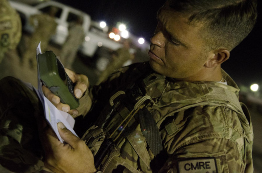
Spc. Carl Arenberg, horizontal construction engineer, 779th Engineer Company, prepares his Defense Advanced GPS Receiver (DAGR) for the night orienteering course during the 2014 U.S. Army Central Solider/NCO of the Year competition at Camp Buehring, Kuwait, May 19, 2014. DARPA is working to develop technology that will allow military personal in aircraft and maritime vessels to navigate even when GPS is denied to them by the enemy. With further development, the technology will be useful for ground navigation as well. [Photo Credit: Sgt. Ryan Hallock]
The "Spatial, Temporal and Orientation Information in Contested Environments" project, or STOIC, is meant to provide position navigation and timing in situations where GPS is denied to U.S. forces, he said.
"Right now we don't have a back-up PNT [positioning, navigation, and timing] system that provides global coverage," he said. "That's what STOIC is researching -- can we provide a backup?"
The STOIC system makes use of very low frequency (or VLF) signals already being generated by the Navy for use in communicating with submarines. The VLF stations are located around the globe in fixed locations. In part, STOIC uses those signals to triangulate a user's position on the globe, in much the same way a GPS receiver is used.
Haas had a video display at the Pentagon that demonstrated how some of their work might be applied. On the screen was an overview of a vehicle traveling along a route. Three lines on the screen traced the route of the vehicle's position.
A yellow line was produced by GPS and was extremely accurate in following the vehicle along the road it traveled. A red line traced the vehicle's route using inertial navigation -- which uses things like a gyroscope and inertial sensors to measure a vehicle's movement away from a previously known point. The inertial navigation system was accurate for a while, then sharply diverged away from the actual route, never to return. Because they don't use any external reference, inertial navigation systems are known to compound on their own errors.
Finally, a green line showed navigation traced by a combination of inertial navigation plus use of a VLF signal. The green line danced erratically around the actual route, but never wandered too far from the vehicle.
"We took one day to plug the VLF receiver into the navigation system, and this is the result we got when driving," Haas said. "No months of optimization."
Haas said one of the reasons the green line danced around the screen was due to magnetic interference from things in the vicinity that affect the VLF signals. There was no mitigation for that kind of interference in their initial field tests, he said. But they will work on that to correct it. Additionally, he said, such interference isn't a problem in the air or on the sea -- so that's where they are focusing their efforts now.
"Once we get the foundation for that system in place, there is a lot of work we need to do in terms of developing VLF measurement models," he said.
Haas said an important aspect of using VLF to provide PNT for use in place of GPS is to measure how various terrain affects the VLF signal, and to incorporate that information into the systems that will use VLF for navigation.
"We've got a lot of hard work to do there," he said. "After that, that is when we want to focus on ground applications, and using the signals indoors. VLF can pick up indoors."
Haas said they are shooting to demonstrate real-time positioning with their system by fiscal year 2018 or 2019. There will also be an at-sea demo this summer.
Interested in other GPS alternatives? See the Designfax article "Extreme miniaturization: 7 devices in one chip navigate without GPS."
Published June 2016
Rate this article
View our terms of use and privacy policy